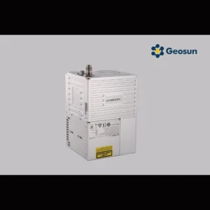
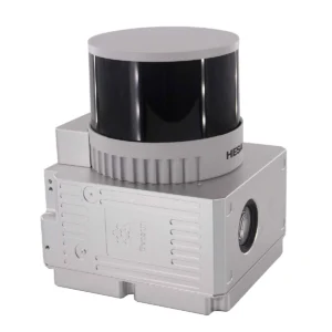
Filter Default sorting Sort by popularity Sort by latest Sort by price: low to high Sort by price: high to low View: 40 80 All 2.15kg VTOL Fixed Wing Drone Livox T15 128 beam UAV LiDAR System 2.1kg 20W HESAI Pandar 40P airborne 3D Mapping Drone LiDAR Geosun GS-260F RTK Model 20 Channel Lidar Uav Mobile Mapping System HESAI Pandar 20B 200M AGL 3D Mapping DJI L1 Laser Mobile LiDAR System 20W 450m Mapping Surveying DJI M600 UAV LiDAR System 32 Channel short Range LiDAR Scanner On GS-800 Multi Rotor Drone 3D Mapping for Mine Drone LiDAR Scanning System Geosun GS-130X Colored Point Cloud High Accuracy 3D Surveying 300M AGL LiDAR Scanning System With VTOL Fixed Wing Drone 450M Lidar Terrain Surveying DJI M600 Pro UAV LiDAR System 500kv Power Line Inspection Drone LiDAR Scanning System Geosun GS-260X PPK RTK Processing 905nm 200m DJI M600 PRO Mounted LiDAR Mobile Mapping System Avirlink L Avirlink S BRDRC Bottom Sensor Cover for DJI Avata Compact Multispectral Camera LiDAR Scanning System For Forestry CrystalSky Remote Controller Mounting Bracket D-RTK 2 Base Station LAN Cable DJI ACE WayPoint DJI Cellular Dongle DJI Cellular Dongle 2 DJI D-Rtk 2 Base Station Tripod DJI Datalink Pro DJI Drone Mount LiDAR Scanning System With Livox Avia Laser Sensor DJI FPV Goggles Sponge Foam Padding DJI Guidance DJI Lightbridge DJI manifold DJI Matrice 300 Series Part10 – Dual Gimbal Connector DJI Matrice 300 Series Upward Gimbal Connector DJI O3 Air Unit 3-in-1 Cable DJI O3 Air Unit Transmission Module DJI PSDK Mounting Bracket DJI X-Port DJI Zenmuse Z15-5D DJI Zenmuse Z15-A7 DJI Zenmuse Z15-BMPCC Drone Lidar Scanner Geosun GS-130X 3D Scanning Built-In RGB Camera Total Aerial Solution DJI M300 Cost Effective Drone Surveying HESAI Pandar40p Laser Scanner Geosun GS-260F LiDAR Scanning System EFT EPS220 EFT EPS240 eSurvey E100 Fixed Wing Drone UAV LiDAR GS-130X HESAI XT32 Sensor 1.26KG 3D Mapping Strong Penetration Forestry Powerline Surveying GAirHawk GS 130H 2km2 Livox Horizon 3D Scanning LiDAR Geosun DJI M600 Drones Mounting Kits LiDAR Accessories Geosun gAirHawk Series GS-100V LiDAR Scanning System HESAI XT16 Laser Sensor Built-In Camera High Precision Aerial Scan GEOSUN GAirHawk Series GS-1500N LiDAR Scanning System 8 Echos Long Detection Aerial VTOL Mapping Geosun gAirHawk Series GS-2000N LiDAR Scanning System 7 Echos Long Detection Aerial VTOL Mapping High Accuracy GEOSUN GAirHawk Series GS-2000N LiDAR Scanning System Long Detection Airborne Mapping Geosun gAirHawk Series GS-260X LiDAR Scanning System City Construction 3D Modeling High Accuracy Colored Point Cloud Geosun gAirHawk Sesries GS-100C+ LiDAR Scanning System Entry-Level 3D Data Collection Livox Avia Sensor Supprt UAV Drone Geosun GS 260P 3D Spatial Data Collection Drone Mounted Lidar GEOSUN GS-100V UAV LiDAR System 360 Degree Fov Laser Sensor Colored Point Cloud Free Software Geosun GS-130X 3D Tower Mapping Modeling UAV LiDAR Scanning System Geosun GS-260X Drone LiDAR Scanning System Geosun Mobile LiDAR System GS 100M+ Livox Avia Laser Vehicle Mounted UAV LiDAR System GS-260F RTK Model Drone LiDAR Scanner HESAI Pandar40P Multi Platform Free Trajectory Processing HESAI Pandar 20B Topographic Mapping UAV LiDAR System HESAI XT Laser Sensor 1.6 Km2 LiDAR Scanning System For 3D Scanning Hi-Target V60 GNSS RTK System High Accuracy UAV LiDAR System with Wide Field of View Lack Lightweight DJI M210 M300 M600 Pro DJI Drones Kits Land Surveying Vtol LiDAR Long Detection Geosun gAirHawk GS-2000N Laser Scanning VTOL Uav Lidar Scanner Five Echo Trajectory Lidar Scanner Drone Long Detection Range 750g 1.92km2 Operation 3D Mapping UAV LiDAR System Long Range Laser Scanning VTOL UAV Vehicle Supported Five Echo Colored Point Cloud Free Trajectory Processing Multi Rotor LiDAR Drone For Inspection Mapping Surveying Security Multi Rotor LiDAR Drone Safety Aircraft Aerial Survey Operation Support Multispectral Camera Laser Sensor 0.88 Km2 UAV Lidar Systems Payload Software Development Kit 2.0 PGYTECH DJI RC Pro Protector PGYTECH DJI RC Protector PGYTECH DJI RC/RC2 Protector PGYTECH Protector for DJI Smart Controller PGYTECH Type-C to Type-C Cable 65cm Power Line Inspection Aerial Mapping UAV LiDAR Drone Mapping 3D Data Collection Colored Point Cloud High Accuracy Reservoir Mapping Drone LiDAR Scanning System DEM Output GS-130X HESAI XT32 RTK Model LiDAR Scanning System Lidar Scanner For Drones Versatile Application SJRC F11 ORIGINAL WIFI MODULE SJRC F11 Pro 4K Drone Sparepart Led Cover SJRC F11/F11S ORIGINAL VISUAL CABLE 1 2