Terrain Mapping Drop 900m Long Range Detection UAV LiDAR Scanning Support VTOL Airborne High Accuracy DEM
Terrain Mapping Long Range Detection LiDAR Scanning Support VTOL Airborne High Accuracy DEM
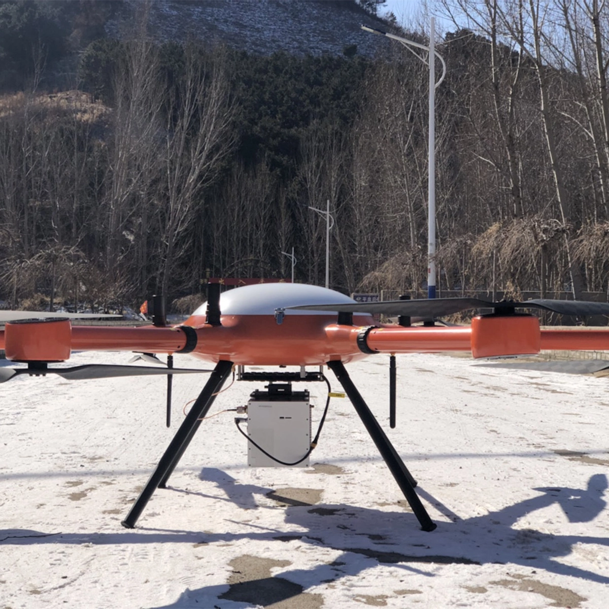
Geosun gAirHawk Series GS-2000N UAV LiDAR Scanning System
UAV LiDAR Scanning System gAirHawk GS-2000N is a kind of long range, compact LiDAR point cloud data acquisition system, integrated FT-1500H long range laser scanner, GNSS and IMU positioning and attitude determination system, and storage control unit, is able to real-time, dynamically, massively collect high-precision point cloud data and rich image information. It is widely used in the acquisition of 3D spatial information in surveying, electricity, forestry, agriculture, land planning.
Application of UAV LiDAR Scanning System gAirHawk GS-2000N
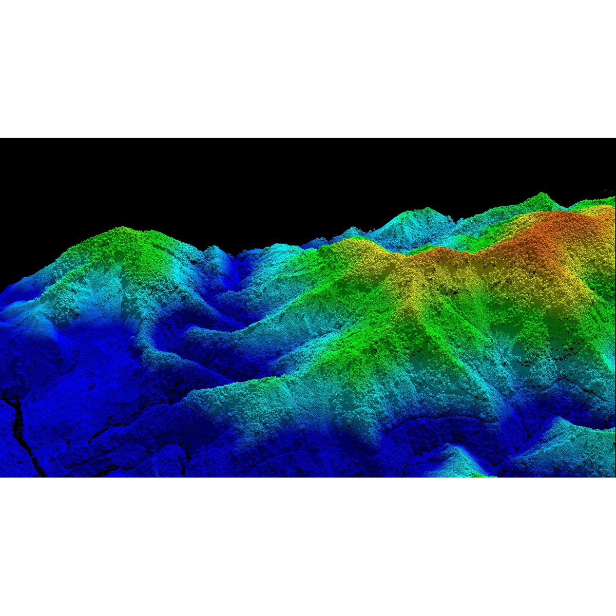
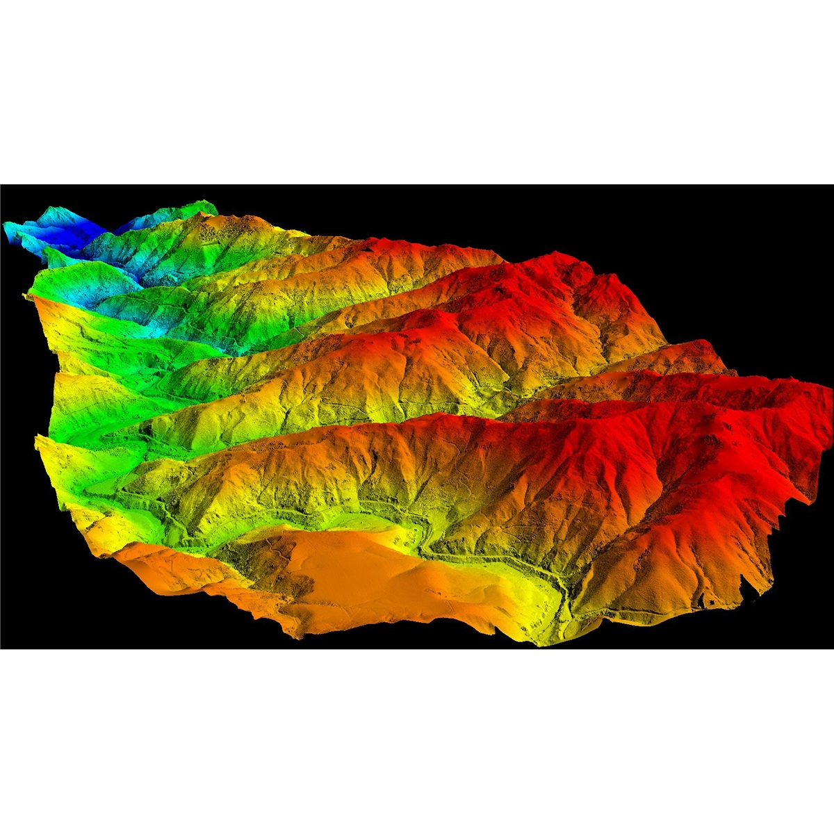
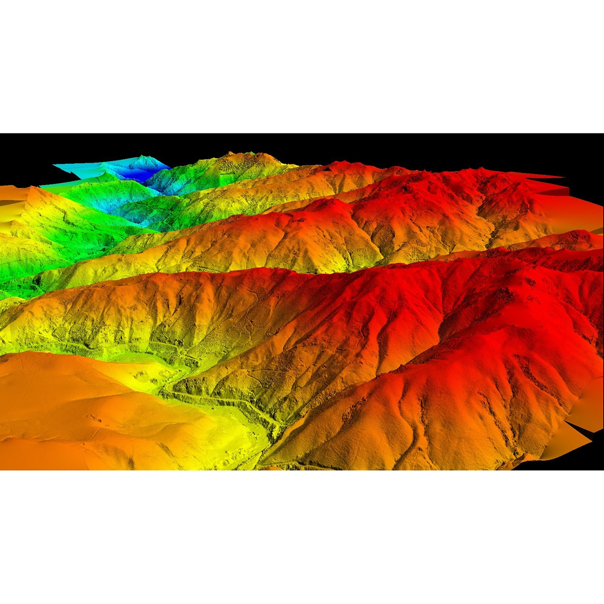
GS-2000N Columbia is being used in a manned aircraft project, with a terrain drop of 900 meters and a high flight speed of 35m/s. With its 2 million pulses per second high frequency, the 1350N is perfectly suited for airborne applications within the 75-90° field of view, with a point density four times that of a full-angle laser. Despite the high altitude and speed, the system still maintains a complete power line and excellent penetration performance.
| Name: | UAV LiDAR Scanning System | Operation Efficency: | 2.8 K㎡ Per Single Flight |
|---|---|---|---|
| Application: | Topography, Forestry, Powerline, Smart City | Channel: | Mapping & Survey |
| Material: | Aluminum Alloy Body | Accuracy: | ≤10cm@600m |
| Dimension: | 245*140.5*125mm | Weight: | 3.2kg |
| Storage: | 64GB Max Support 128GB TF Card | Working Temperature: | -20°~+55° |
| Carry Platform: | Multi-Rotor, VTOL | Trajectory Software: | Shuttle |
| Point Cloud Software: | GAirHawk | ||
| Highlight: |
UAV VTOL LiDAR Scanning, Terrain Mapping VTOL LiDAR Scanning, Long Range UAV LiDAR System |
||
Spesifikasi
| uav LiDAR scanning system gAirHawk GS-2000N | ||
| Item Name | System Parameters | |
|
GS-2000N
Parameters |
Weight | 3.2kg |
| Working temperature | -20℃~+60℃ | |
| Power range | 12V- 24V | |
| Consumption | 65W | |
| Carrying Platform | 6 Aixs Multi Rotor Drone | |
| Storage | 64 GB storage, maximum support 128GB TF card | |
| Laser Unit
|
Measuring Range | 2000m@80% |
| Laser class | 1550 nm Class1 (IEC 60825-1:2014) | |
| Laser line number | FT-1500H Single-Beam | |
| Measuring accuracy | 3mm@100m | |
| Max. range | 2000m | |
| Return | 7 echos | |
| Pulse frequency | 50 HZ-2000HZ | |
| Beam Divergence | 0.3mrad | |
| FOV | 75°-90°, adjustable | |
| POS Unit | Update frequency | 200HZ |
| Heading accuracy | 0.010° | |
| Pitch accuracy | 0.003° | |
| Rolling accuracy | 0.003° | |
| Position accuracy | Horizontal: 0.02m, Vertical: 0.03m | |
| GNSS signal type | GPSL1/L2/L5 GLONASSL1/L2 BDS B1/B2/B3 GAL E1/E5a/5b | |
| IMU | gSpin 410 | |
| Pre-processing software | POS software | Output information: position, speed, attitude |
| Point cloud software | Output point cloud data format: LAS format, custom TXT format | |
| Camera (built-in) | FOV | 48*33 Degree |
| Effective Pixel | 45 MP (Full Frame Camera) | |
| focal Length(mm) | 16 | |
Video
Dokumen
 Pusatdrone.com
Kompleks Ruko 66, Jl. Pinangsia Raya Ruko No.66F, RT.3/RW.5, Pinangsia, Kota Jakarta Barat
-
barang original dan baru cs WA sangat membantu dan ramah
-
-
-
-
-
respon cepet pelayan bagus
-
Fast respon dan ramah
-
Pelayanan memuaskan is the best
-
Fast response
-
Informatif dan membantu
-
Rekomen banget, adminnya ramah dan super responsif. Sangat cocok buat kamu yg mau tanya-tanya dulu sebelum beli.
-
lokasinya nggak jauh dari stasiun Jakarta Kota, ownernya helpful banget dan care membantu memperbaiki propeler drone saya....Terimakasih banyak koko
-
pelayanan ramah dan sangat baik, barang yang dijual original no kw kw, dan sudah berkali-kali berlangganan tidak ada masalah apapun. sangat bertanggungjawab, best !
-
Respon dari tim pusat drone sangat cepat dan ramah. Setiap pertanyaan langsung dijawab dengan jelas, baik melalui chat maupun telepon. Jadi lebih yakin sebelum memutuskan untuk beli/servis.
-
-
-
-
Pokoknya recommended! harga oke, barang sesuai, pengiriman cepet,adminnya fast respon dan ramah parah.pokoknya the best deh!
-
layanan bagus keren dan terpercaya
-
Layanan mantap, memuaskan.keren banget
-
Keren
-
Pelayanan nya baik
-
-
-
wah mantep ini tempatnya, keren kacau!!
-
the best
-
Layanan yang sangat bagus dan produknya berkualitas
-
Kesini di rekomendasi teman, krn super fast respon dan sales consultant nya helpfull banget, super detail jelasin product, Gokil!!
-
melayani sangat baik
-
-
Saya sangat dibantu oleh team pusat drone, dari konsultasi sesuai kebutuhan, pelayanan terbest, harganya juga sangat terjangkau, rekomend banget pokoknya


